
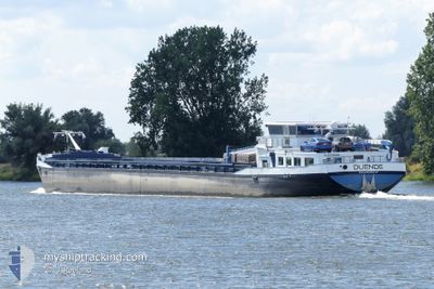
DUENDE
Cargo
Current Trip
ZEIL AM MAIN
| Time Travelled | 13 h, 55 mins |
|---|---|
| Remaining Time | --- |
| Distance Travelled | 43.37 nm |
| Remaining Distance | --- |
| AVG Speed | 4.8 Knots |
| MAX Speed | 7 Knots |
| AVG Wind | 6 knots |
| MAX Wind | 7 knots |
| MIN Temp | 0.2°C / 32.36°F |
| MAX Temp | 1.6°C / 34.88°F |
| Draught | 2.3 m |
| Position Received | 8 m ago |
Current Position
| Longitude | 6.63272° |
|---|---|
| Latitude | 49.76512° |
| Status | Under way using engine |
| Speed | 5.9 Knots |
| Course | 30.3° |
| Area | North Sea |
| Station | T-AIS |
| Position Received | 8 m ago |
Info
Information
The current position of DUENDE is in North Sea with coordinates 49.76512° / 6.63272° as reported on 2026-01-08 20:29 by AIS to our vessel tracker app. The vessel's current speed is 5.9 Knots
The vessel DUENDE (MMSI: 244730568) is a Cargo It's sailing under the flag of [NL] Netherlands.
In this page you can find informations about the vessels current position, last detected port calls, and current voyage information. If the vessels is not in coverage by AIS you will find the latest position.
The current position of DUENDE is detected by our AIS receivers and we are not responsible for the reliability of the data. The last position was recorded while the vessel was in Coverage by the Ais receivers of our vessel tracking app.
The current draught of DUENDE as reported by AIS is 2.3 meters
Weather
| Temperature | 1.7°C / 35.06°F |
|---|---|
| Wind Speed | 6 knots |
| Direction | 154° SSE |
| Pressure | 1001.3 hPa |
| Humidity | 98.3 % |
| Cloud Coverage | 100 % |
Featured Company
Last Port Calls
| Port | Arrival | Departure | Time In Port |
|---|---|---|---|
| 2026-01-06 18:00 | 2026-01-08 07:42 | 1 d | |
| 2025-12-27 12:08 | 2025-12-27 12:43 | 34 m | |
| 2025-12-19 09:02 | 2025-12-19 09:37 | 35 m | |
| 2025-12-19 05:43 | 2025-12-19 06:20 | 36 m | |
| 2025-12-17 21:24 | 2025-12-19 05:32 | 1 d | |
| 2025-12-17 18:58 | 2025-12-17 19:29 | 30 m | |
| 2025-12-16 22:29 | 2025-12-17 05:23 | 6 h | |
| 2025-12-16 17:43 | |||
| 2025-12-12 09:13 | 2025-12-12 19:21 | 10 h | |
| 2025-12-11 11:03 | 2025-12-12 08:13 | 21 h |
Last Trips
| Origin | Departure | Destination | Arrival | Distance | |
|---|---|---|---|---|---|
| 2025-12-27 12:43 | 2026-01-06 18:00 | 302.94 nm | |||
| 2025-12-19 09:37 | 2025-12-27 12:08 | 0.48 nm | |||
| 2025-12-19 06:20 | 2025-12-19 09:02 | 26.48 nm | |||
| 2025-12-19 05:32 | 2025-12-19 05:43 | 1.13 nm | |||
| 2025-12-17 19:29 | 2025-12-17 21:24 | 10.75 nm | |||
| 2025-12-17 05:23 | 2025-12-17 18:58 | 115.31 nm | |||
| 2025-12-16 17:43 | 2025-12-16 22:29 | 35.80 nm | |||
| 2025-12-12 08:13 | 2025-12-12 09:13 | 8.43 nm | |||
| 2025-12-11 07:37 | 2025-12-11 11:03 | 27.08 nm | |||
| 2025-12-10 11:37 | 2025-12-10 21:52 | 70.98 nm |
Events
| Time | Event | Details | Position / Dest | Info |
|---|---|---|---|---|
| 2026-01-08 20:29 | Status Changed | Under way using engine Default |
49.76512 / 6.63272
ZEIL AM MAIN
|
Speed: 5 kn Course: 23° |
| 2026-01-08 20:09 | Status Changed | Default Under way using engine |
49.73500 / 6.62667
ZEIL AM MAIN
|
Speed: Course: 511° |
| 2026-01-08 20:09 | START Moving | 1.51 nm, South of TRIER |
49.73500 / 6.62667
ZEIL AM MAIN
|
Speed: 5 kn Course: 23° |
| 2026-01-08 19:50 | Status Changed | Under way using engine Default |
49.72880 / 6.62170
ZEIL AM MAIN
|
Speed: 1 kn Course: -1° |
| 2026-01-08 19:50 | STOP Moving | 1.91 nm, South of TRIER |
49.72880 / 6.62170
ZEIL AM MAIN
|
Speed: Course: 511° |
| 2026-01-08 19:30 | IN Coverage |
49.72880 / 6.62170
North Sea
|
Speed: Course: 511° |
|
| 2026-01-08 14:24 | STOP Moving | 14.52 nm, South of MERTERT |
49.46667 / 6.36833
ZEIL AM MAIN
|
Speed: Course: -1° |
| 2026-01-08 12:39 | START Moving | 14.68 nm, North of LA MAXE |
49.40167 / 6.27333
ZEIL AM MAIN
|
Speed: 4 kn Course: -1° |
| 2026-01-08 12:15 | STOP Moving | 14.42 nm, North of LA MAXE |
49.39834 / 6.26500
ZEIL AM MAIN
|
Speed: Course: -1° |
| 2026-01-08 08:39 | START Moving | 4.64 nm, North of LA MAXE |
49.23833 / 6.18333
ZEIL AM MAIN
|
Speed: 4 kn Course: -1° |