
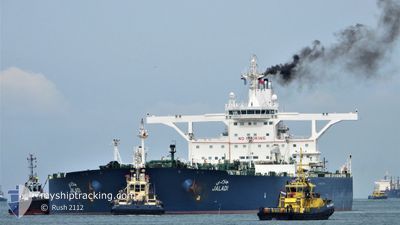
JALADI
Crude Oil Tanker
Current Trip
| Time Travelled | 5 days |
|---|---|
| Remaining Time | 1 day |
| Distance Travelled | 1027.09 nm |
| Remaining Distance | 454.76 nm |
| AVG Speed | 12 Knots |
| MAX Speed | 15.2 Knots |
| AVG Wind | 15.8 knots |
| MAX Wind | 30 knots |
| MIN Temp | 10.8°C / 51.44°F |
| MAX Temp | 24.5°C / 76.1°F |
| Draught | 21.7 m |
| Position Received | 1 d ago |
Current Position
| Longitude | 34.29847° |
|---|---|
| Latitude | 27.24575° |
| Status | Under way using engine |
| Speed | 13.6 Knots |
| Course | 138.5° |
| Area | Red Sea |
| Station | T-AIS |
| Position Received | 1 d ago |
Info
Information
The current position of JALADI is in Red Sea with coordinates 27.24575° / 34.29847° as reported on 2025-02-09 03:02 by AIS to our vessel tracker app. The vessel's current speed is 13.6 Knots and is heading at the port of SOKHNA. The estimated time of arrival as calculated by MyShipTracking vessel tracking app is 2025-02-12 07:36 LT
The vessel JALADI (IMO: 9384227, MMSI: 403591000) is a Crude Oil Tanker that was built in 2009 ( 16 years old ). It's sailing under the flag of [SA] Saudi Arabia.
In this page you can find informations about the vessels current position, last detected port calls, and current voyage information. If the vessels is not in coverage by AIS you will find the latest position.
The current position of JALADI is detected by our AIS receivers and we are not responsible for the reliability of the data. The last position was recorded while the vessel was in Coverage by the Ais receivers of our vessel tracking app.
The current draught of JALADI as reported by AIS is 21.7 meters
Weather
| Temperature | 21.4°C / 70.52°F |
|---|---|
| Wind Speed | 24 knots |
| Direction | 328° NNW |
| Pressure | 1012.3 hPa |
| Humidity | 63 % |
| Cloud Coverage | 100 % |
Featured Company
Last Port Calls
| Port | Arrival | Departure | Time In Port |
|---|---|---|---|
| 2025-02-03 15:04 | 2025-02-05 01:04 | 1 d | |
| 2025-01-18 16:01 | 2025-01-20 03:55 | 1 d | |
| 2025-01-04 11:51 | 2025-01-07 17:46 | 3 d | |
| 2024-12-19 15:21 | 2024-12-21 13:21 | 1 d |
Most Visited Ports (Last year)
| Port | Arrivals | |
|---|---|---|
| 14 | ||
| 7 | ||
| 1 | ||
| 1 |
Last Trips
| Origin | Departure | Destination | Arrival | Distance | |
|---|---|---|---|---|---|
| 2025-01-20 06:55 | 2025-02-03 18:04 | 1632.85 nm | |||
| 2025-01-07 20:46 | 2025-01-18 19:01 | 1225.25 nm | |||
| 2024-12-21 16:21 | 2025-01-04 14:51 | 1253.25 nm | |||
| 2024-11-28 12:43 | 2024-12-19 18:21 | 1366.21 nm |
Events
| Time | Event | Details | Position / Dest | Info |
|---|---|---|---|---|
| 2025-02-09 03:02 | OUT of Coverage |
27.24575 / 34.29847
Red Sea
|
Speed: 13.6 kn Course: 138.5° |
|
| 2025-02-09 03:02 | Status Changed | Under way using engine Default |
27.24575 / 34.29847
EG AIS
|
Speed: 13 kn Course: 143° |
| 2025-02-09 02:36 | Status Changed | Default Under way using engine |
27.32064 / 34.22822
EG AIS
|
Speed: 12.8 kn Course: 142.4° |
| 2025-02-09 01:38 | Detected in Sea | Egyptian part of the Red Sea |
27.47833 / 34.08543
Red Sea
|
Speed: 12.5 kn Course: 136.1° |
| 2025-02-09 01:26 | Status Changed | Under way using engine Default |
27.50849 / 34.05293
EG AIS
|
Speed: 12.4 kn Course: 136° |
| 2025-02-09 01:26 | IN Coverage |
27.50849 / 34.05293
Gulf of Suez
|
Speed: 12.4 kn Course: 136° |
|
| 2025-02-08 13:30 | START Moving | 6.84 nm, South East of SOKHNA |
29.58360 / 32.47071
EG AIS
|
Speed: 11.3 kn Course: 121° |
| 2025-02-08 12:32 | STOP Moving | 5.49 nm, South East of SOKHNA |
29.59700 / 32.44987
EG AIS
|
Speed: 0.2 kn Course: 36° |
| 2025-02-08 11:31 | START Moving | 4.3 nm, South of SOKHNA |
29.57608 / 32.37848
EG AIS
|
Speed: 5.9 kn Course: 46° |
| 2025-02-06 21:46 | STOP Moving | 5.15 nm, South of SOKHNA |
29.56273 / 32.38498
EG AIS
|
Speed: 0.3 kn Course: 303° |