
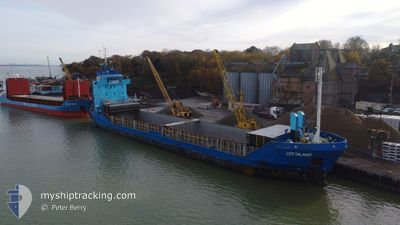
LOTTALAND
General Cargo
Current Trip
| Time Travelled | 20 h, 5 mins |
|---|---|
| Remaining Time | 2 days |
| Distance Travelled | 154.86 nm |
| Remaining Distance | 522.65 nm |
| AVG Speed | 7.7 Knots |
| MAX Speed | 13.6 Knots |
| AVG Wind | 11.2 knots |
| MAX Wind | 13.8 knots |
| MIN Temp | 0.8°C / 33.44°F |
| MAX Temp | 6.1°C / 42.98°F |
| Draught | 5.2 m |
| Position Received | Now |
Current Position
| Longitude | 11.90320° |
|---|---|
| Latitude | 54.39422° |
| Status | Under way using engine |
| Speed | 10.3 Knots |
| Course | 88.6° |
| Area | Baltic Sea |
| Station | T-AIS |
| Position Received | Now |
Info
Information
The current position of LOTTALAND is in Baltic Sea with coordinates 54.39422° / 11.90320° as reported on 2025-02-01 00:01 by AIS to our vessel tracker app. The vessel's current speed is 10.3 Knots and is heading at the port of TURKU. The estimated time of arrival as calculated by MyShipTracking vessel tracking app is 2025-02-03 05:19 LT
The vessel LOTTALAND (IMO: 9155975, MMSI: 275504000) is a General Cargo that was built in 1997 ( 28 years old ). It's sailing under the flag of [LV] Latvia.
In this page you can find informations about the vessels current position, last detected port calls, and current voyage information. If the vessels is not in coverage by AIS you will find the latest position.
The current position of LOTTALAND is detected by our AIS receivers and we are not responsible for the reliability of the data. The last position was recorded while the vessel was in Coverage by the Ais receivers of our vessel tracking app.
The current draught of LOTTALAND as reported by AIS is 5.2 meters
Weather
| Temperature | 4.2°C / 39.56°F |
|---|---|
| Wind Speed | 12 knots |
| Direction | 290° WNW |
| Pressure | 1029.1 hPa |
| Humidity | 92.2 % |
| Cloud Coverage | 62 % |
Featured Company
Last Port Calls
| Port | Arrival | Departure | Time In Port |
|---|---|---|---|
| 2025-01-29 03:26 | 2025-01-31 04:56 | 2 d | |
| 2025-01-23 10:54 | 2025-01-25 11:10 | 2 d | |
| 2025-01-21 08:53 | 2025-01-22 01:58 | 17 h | |
| 2025-01-16 08:54 | 2025-01-18 01:41 | 1 d | |
| 2025-01-12 20:13 | 2025-01-15 19:29 | 2 d | |
| 2025-01-09 01:49 | 2025-01-10 13:38 | 1 d | |
| 2025-01-05 19:08 | 2025-01-08 02:20 | 2 d | |
| 2024-12-19 19:45 | 2024-12-23 15:29 | 3 d | |
| 2024-12-17 23:09 | 2024-12-19 19:25 | 1 d | |
| 2024-12-16 03:19 | 2024-12-16 16:37 | 13 h |
Last Trips
| Origin | Departure | Destination | Arrival | Distance | |
|---|---|---|---|---|---|
| 2025-01-25 11:10 | 2025-01-29 03:26 | 678.65 nm | |||
| 2025-01-22 01:58 | 2025-01-23 10:54 | 327.05 nm | |||
| 2025-01-18 01:41 | 2025-01-21 08:53 | 779.25 nm | |||
| 2025-01-15 19:29 | 2025-01-16 08:54 | 53.09 nm | |||
| 2025-01-10 13:38 | 2025-01-12 20:13 | 569.74 nm | |||
| 2025-01-08 02:20 | 2025-01-09 01:49 | 233.97 nm | |||
| 2024-12-23 15:29 | 2025-01-05 19:08 | 495.67 nm | |||
| 2024-12-19 19:25 | 2024-12-19 19:45 | 1.16 nm | |||
| 2024-12-16 16:37 | 2024-12-17 23:09 | 279.63 nm | |||
| 2024-12-14 21:49 | 2024-12-16 03:19 | 303.91 nm |
Events
| Time | Event | Details | Position / Dest | Info |
|---|---|---|---|---|
| 2025-01-31 22:19 | Detected in Sea | Danish part of the Baltic Sea |
54.50048 / 11.43982
Baltic Sea
FITKU
|
Speed: 10.2 kn Course: 113.7° |
| 2025-01-31 19:58 | Detected in Sea | German part of the Baltic Sea |
54.56613 / 10.78087
Baltic Sea
FITKU
|
Speed: 10.4 kn Course: 84.5° |
| 2025-01-31 19:22 | Change Sea Area | Danish part of the Baltic Sea German part of the Baltic Sea |
54.55637 / 10.60223
Baltic Sea
FITKU
|
Speed: 10.4 kn Course: 84.3° |
| 2025-01-31 18:04 | Change Sea Area | German part of the Baltic Sea German part of the North Sea |
54.46081 / 10.26498
Baltic Sea
FITKU
|
Speed: 10.4 kn Course: 36.7° |
| 2025-01-31 17:19 | START Moving | 1.31 nm, South West of STICKENHΟRN SPORT |
54.36572 / 10.14481
FITKU
|
Speed: 4.2 kn Course: 100° |
| 2025-01-31 16:19 | STOP Moving | 1.36 nm, South West of STICKENHΟRN SPORT |
54.36620 / 10.14172
FITKU
|
Speed: 0.3 kn Course: 104° |
| 2025-01-31 16:10 | START Moving | 1.6 nm, South West of STICKENHΟRN SPORT |
54.36713 / 10.13101
FITKU
|
Speed: 3.1 kn Course: 94° |
| 2025-01-31 15:54 | STOP Moving | 1.7 nm, South West of STICKENHΟRN SPORT |
54.36780 / 10.12673
FITKU
|
Speed: 0.3 kn Course: 113° |
| 2025-01-31 14:56 | START Moving | 6.69 nm, West of KIEL |
54.34259 / 9.96986
FITKU
|
Speed: 3.2 kn Course: 71° |
| 2025-01-31 14:33 | STOP Moving | 6.84 nm, West of KIEL |
54.34209 / 9.96556
FITKU
|
Speed: 0.2 kn Course: 81° |