

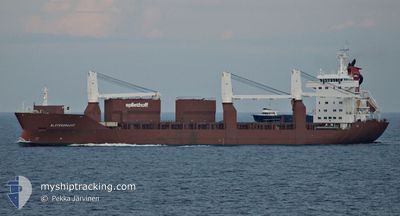
SLOTERGRACHT
General Cargo

Current Trip
| Time Travelled | 2 days |
|---|---|
| Remaining Time | 8 days |
| Distance Travelled | 798.12 nm |
| Remaining Distance | 2590.02 nm |
| AVG Speed | 14 Knots |
| MAX Speed | 22.2 Knots |
| AVG Wind | 16 knots |
| MAX Wind | 26 knots |
| MIN Temp | 14.2°C / 57.56°F |
| MAX Temp | 21.1°C / 69.98°F |
| Draught | 7.1 m |
| Position Received | 1 d ago |
Current Position
| Longitude | -75.04755° |
|---|---|
| Latitude | 35.11771° |
| Status | Under way using engine |
| Speed | 17.9 Knots |
| Course | 48.2° |
| Area | North Atlantic Ocean |
| Station | T-AIS |
| Position Received | 1 d ago |
Information
The current position of SLOTERGRACHT is in North Atlantic Ocean with coordinates 35.11771° / -75.04755° as reported on 2025-03-30 07:51 by AIS to our vessel tracker app. The vessel's current speed is 17.9 Knots and is heading at the port of MONTOIR. The estimated time of arrival as calculated by MyShipTracking vessel tracking app is 2025-04-09 11:53 LT
The vessel SLOTERGRACHT (IMO: 9197947, MMSI: 246456000) is a General Cargo that was built in 2000 ( 25 years old ). It's sailing under the flag of [NL] Netherlands.
In this page you can find informations about the vessels current position, last detected port calls, and current voyage information. If the vessels is not in coverage by AIS you will find the latest position.
The current position of SLOTERGRACHT is detected by our AIS receivers and we are not responsible for the reliability of the data. The last position was recorded while the vessel was in Coverage by the Ais receivers of our vessel tracking app.
The current draught of SLOTERGRACHT as reported by AIS is 7.1 meters
Weather
| Temperature | 15.2°C / 59.36°F |
|---|---|
| Wind Speed | 26 knots |
| Direction | 209° SSW |
| Pressure | 1015.4 hPa |
| Humidity | 87.1 % |
| Cloud Coverage | 95 % |


Featured Company
Last Port Calls
| Port | Arrival | Departure | Time In Port |
|---|---|---|---|
| 2025-03-29 10:34 | 2025-03-29 20:01 | 9 h | |
| 2025-03-18 18:21 | 2025-03-23 13:35 | 4 d | |
| 2025-03-08 08:33 | 2025-03-08 20:54 | 12 h | |
| 2025-02-26 16:02 | 2025-03-03 19:12 | 5 d | |
| 2025-02-24 12:49 | 2025-02-25 22:21 | 1 d | |
| 2025-02-07 01:18 | 2025-02-08 03:24 | 1 d | |
| 2025-02-07 00:15 | 2025-02-07 00:24 | 9 m | |
| 2025-02-06 08:47 | 2025-02-06 15:17 | 6 h | |
| 2025-02-04 02:05 | 2025-02-05 19:40 | 1 d | |
| 2025-02-02 07:22 | 2025-02-03 14:24 | 1 d |
Last Trips
| Origin | Departure | Destination | Arrival | Distance | |
|---|---|---|---|---|---|
| 2025-03-23 13:35 | 2025-03-29 10:34 | 380.16 nm | |||
| 2025-03-08 20:54 | 2025-03-18 18:21 | 3375.17 nm | |||
| 2025-03-03 19:12 | 2025-03-08 08:33 | 1687.89 nm | |||
| 2025-02-25 22:21 | 2025-02-26 16:02 | 155.40 nm | |||
| 2025-02-08 03:24 | 2025-02-24 12:49 | 4892.83 nm | |||
| 2025-02-07 00:24 | 2025-02-07 01:18 | 3.57 nm | |||
| 2025-02-06 15:17 | 2025-02-07 00:15 | 1.18 nm | |||
| 2025-02-05 19:40 | 2025-02-06 08:47 | 94.20 nm | |||
| 2025-02-03 14:24 | 2025-02-04 02:05 | 161.62 nm | |||
| 2025-01-29 18:41 | 2025-02-02 07:22 | 1426.28 nm |
Events
| Time | Event | Details | Position / Dest | Info |
|---|---|---|---|---|
| 2025-03-30 07:59 | Status Changed | Default Under way using engine |
35.13425 / -75.00694
FRMTX
|
Speed: 17.9 kn Course: 48.2° |
| 2025-03-30 07:51 | OUT of Coverage |
35.11771 / -75.04755
North Atlantic Ocean
FRMTX
|
Speed: 17.9 kn Course: 48.2° |
|
| 2025-03-30 04:20 | Status Changed | Under way using engine Default |
34.59235 / -76.01655
FRMTX
|
Speed: 15.8 kn Course: 57° |
| 2025-03-30 03:44 | Status Changed | Default Under way using engine |
34.50601 / -76.17894
FRMTX
|
Speed: 15.7 kn Course: 55.5° |
| 2025-03-30 00:01 | PORT DEPARTURE |
|
34.71332 / -76.69448
FRMTX
|
Speed: 7.2 kn Course: 138° |
| 2025-03-29 23:58 | Status Changed | Under way using engine Moored |
34.71435 / -76.70319
[US] MOREHEAD CITY
|
Speed: 4.5 kn Course: 93° |
| 2025-03-29 23:56 | START Moving |
34.71453 / -76.70500
[US] MOREHEAD CITY
|
Speed: 3.3 kn Course: 93° |
|
| 2025-03-29 23:31 | Draught Changed | 7.1 7.2 |
34.71529 / -76.70077
[US] MOREHEAD CITY
|
Speed: Course: 265° |
| 2025-03-29 23:25 | Status Changed | Moored Under way using engine |
34.71531 / -76.70076
[US] MOREHEAD CITY
|
Speed: Course: 265° |
| 2025-03-29 23:25 | Status Changed | Under way using engine Moored |
34.71530 / -76.70076
[US] MOREHEAD CITY
|
Speed: Course: 265° |