

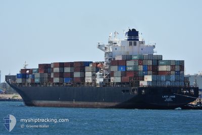
LADY JANE
Container Ship

Current Trip
NIN=>TIJ
| Time Travelled | 8 h, 32 mins |
|---|---|
| Remaining Time | --- |
| Distance Travelled | 125.14 nm |
| Remaining Distance | --- |
| AVG Speed | 15.1 Noeuds |
| MAX Speed | 15.9 Noeuds |
| AVG Wind | 17.9 knots |
| MAX Wind | 20.6 knots |
| MIN Temp | 16.4°C / 61.52°F |
| MAX Temp | 20.9°C / 69.62°F |
| Tirant d eau | 12.2 m |
| Position reçue | 1 d depuis |
Current Position
| Longitude | -116.88820° |
|---|---|
| Latitude | 31.70849° |
| Etat | Under way using engine |
| Vitesse | 14.6 Noeuds |
| Parcours | 60.1° |
| Zone | North Pacific Ocean |
| Station | T-AIS |
| Position reçue | 1 d depuis |
Information
The current position of LADY JANE is in North Pacific Ocean with coordinates 31.70849° / -116.88820° as reported on 2025-06-07 15:10 by AIS to our vessel tracker app. The vessel's current speed is 14.6 Noeuds
The vessel LADY JANE (IMO: 9297474, MMSI: 538009624) is a Container Ship that was built in 2005 ( 20 Age ). It's sailing under the flag of [MH] Marshall Is.
In this page you can find informations about the vessels current position, last detected port calls, and current voyage information. If the vessels is not in coverage by AIS you will find the latest position.
The current position of LADY JANE is detected by our AIS receivers and we are not responsible for the reliability of the data. The last position was recorded while the vessel was in Coverage by the Ais receivers of our vessel tracking app.
The current draught of LADY JANE as reported by AIS is 12.2 meters
Weather
| Temperature | 16.6°C / 61.88°F |
|---|---|
| Wind Speed | 19 knots |
| Direction | 327° NNW |
| Pressure | 1012.3 hPa |
| Humidity | 90.9 % |
| Cloud Coverage | 7 % |


Featured Company
Last Trips
| Origin | Departure | Destination | Arrival | Distance | |
|---|---|---|---|---|---|
| 2025-05-20 18:18 | 2025-06-07 20:11 | 6153.46 nm | |||
| 2025-05-04 15:21 | 2025-05-19 20:26 | 6273.87 nm | |||
| 2025-04-10 11:11 | 2025-04-27 17:48 | 4939.32 nm | |||
| 2025-04-05 15:22 | 2025-04-09 20:17 | 1466.22 nm | |||
| 2025-03-29 10:41 | 2025-04-05 05:05 | 1069.68 nm |
Events
| Heure | Evenement | Détails | Position/ Destination | Info |
|---|---|---|---|---|
| 2025-06-08 17:24 | PORT DE DEPART |
|
31.83858 / -116.62408
NIN=>TIJ
|
Vitesse: 5.6 kn Parcours: 153° |
| 2025-06-08 17:18 | Démarrage |
31.84876 / -116.62575
[MX] ENSENADA
|
Vitesse: 5.6 kn Parcours: 153° |
|
| 2025-06-08 03:36 | Arret |
31.85251 / -116.62944
[MX] ENSENADA
|
Vitesse: Parcours: 149° |
|
| 2025-06-08 03:11 | Port d'arrivée |
|
31.84928 / -116.62573
[MX] ENSENADA
|
Vitesse: 4.4 kn Parcours: 6° |
| 2025-06-08 02:11 | Démarrage | 4.02 nm, South West of ENSENADA |
31.79643 / -116.66659
NIN=>TIJ
|
Vitesse: 5.1 kn Parcours: 58° |
| 2025-06-07 16:18 | Arret | 4.63 nm, South West of ENSENADA |
31.78759 / -116.67244
NIN=>TIJ
|
Vitesse: 0.3 kn Parcours: 350° |
| 2025-06-07 15:18 | Etat Changé | Default Under way using engine |
31.72672 / -116.85053
NIN=>TIJ
|
Vitesse: 14.6 kn Parcours: 60.1° |
| 2025-06-07 15:10 | Etat Changé | Under way using engine Default |
31.70849 / -116.88820
NIN=>TIJ
|
Vitesse: 22.2 kn Parcours: 58° |
| 2025-06-07 15:10 | Hors de la zone couverte |
31.70849 / -116.88820
North Pacific Ocean
NIN=>TIJ
|
Vitesse: 14.6 kn Parcours: 60.1° |
|
| 2025-06-07 14:22 | Etat Changé | Default Under way using engine |
31.62785 / -117.06184
NIN=>TIJ
|
Vitesse: 12.7 kn Parcours: 67° |