
AFRICAN CRATE
Cargo
Current Trip
| Time Travelled | 4 days |
|---|---|
| Remaining Time | --- |
| Distance Travelled | 1312.10 nm |
| Remaining Distance | --- |
| AVG Speed | 11.9 Knopen |
| MAX Speed | 14.5 Knopen |
| AVG Wind | 10.4 knots |
| MAX Wind | 31 knots |
| MIN Temp | -1.4°C / 29.48°F |
| MAX Temp | 6.5°C / 43.7°F |
| Diepgang | 10 M |
| Positie ontvangen | 4 d geleden |
Current Position
| Lengtegraad | -126.13270° |
|---|---|
| Breedtegraat | 48.51707° |
| Status | Under way using engine |
| Snelheid | 12.5 Knopen |
| Koers | 269° |
| Gebied | North Pacific Ocean |
| Station | T-AIS |
| Positie ontvangen | 4 d geleden |
Info
Information
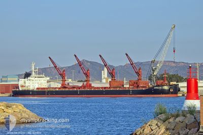
The current position of AFRICAN CRATE is in North Pacific Ocean with coordinates 48.51707° / -126.13270° as reported on 2025-02-08 14:36 by AIS to our vessel tracker app. The vessel's current speed is 12.5 Knopen and is heading at the port of NAGOYA. The estimated time of arrival as calculated by MyShipTracking vessel tracking app is 2025-02-25 21:00 LT
The vessel AFRICAN CRATE (IMO: 9657870, MMSI: 311001318) is a Cargo It's sailing under the flag of [BS] Bahamas.
In this page you can find informations about the vessels current position, last detected port calls, and current voyage information. If the vessels is not in coverage by AIS you will find the latest position.
The current position of AFRICAN CRATE is detected by our AIS receivers and we are not responsible for the reliability of the data. The last position was recorded while the vessel was in Coverage by the Ais receivers of our vessel tracking app.
The current draught of AFRICAN CRATE as reported by AIS is 10 meters
Weather
| Temperature | 2.6°C / 36.68°F |
|---|---|
| Wind Speed | 21 knots |
| Direction | 15° NNE |
| Pressure | 1004.3 hPa |
| Humidity | 98 % |
| Cloud Coverage | 100 % |
Featured Company
Last Port Calls
| Port | Arrival | Departure | Time In Port |
|---|---|---|---|
| 2025-02-06 06:49 | 2025-02-07 14:27 | 1 d | |
| 2025-01-07 13:37 | 2025-01-11 08:52 | 3 d | |
| 2024-12-19 10:57 | 2024-12-20 20:27 | 1 d | |
| 2024-12-04 22:12 | 2024-12-06 17:44 | 1 d |
Most Visited Ports (Last year)
| Port | Arrivals | |
|---|---|---|
| 1 | ||
| 1 | ||
| 1 | ||
| 1 | ||
| 1 | ||
| 1 |
Last Trips
| Origin | Departure | Destination | Arrival | Distance | |
|---|---|---|---|---|---|
| 2025-01-11 08:52 | 2025-02-06 06:49 | 4947.31 nm | |||
| 2024-12-20 20:27 | 2025-01-07 13:37 | 3533.22 nm | |||
| 2024-12-06 17:44 | 2024-12-19 10:57 | 2954.54 nm | |||
| 2024-11-01 10:53 | 2024-12-04 22:12 | 7665.97 nm |
Events
| Tijd | Evenement | Details | Positie / Bestemming | Info |
|---|---|---|---|---|
| 2025-02-10 00:16 | Start beweging |
50.84258 / -135.16362
JP NGO
|
Snelheid: 5 kn Koers: 292° |
|
| 2025-02-09 22:56 | Stop beweging |
50.82836 / -135.17738
JP NGO
|
Snelheid: 0.3 kn Koers: 143° |
|
| 2025-02-08 14:47 | Status Changed | Default Under way using engine |
48.51633 / -126.18629
JP NGO
|
Snelheid: 12.5 kn Koers: 269° |
| 2025-02-08 14:36 | Buitenbereik |
48.51707 / -126.13270
North Pacific Ocean
JP NGO
|
Snelheid: 12.5 kn Koers: 269° |
|
| 2025-02-08 14:31 | Status Changed | Under way using engine Default |
48.51733 / -126.10578
JP NGO
|
Snelheid: 12.3 kn Koers: 270° |
| 2025-02-08 14:14 | Status Changed | Default Under way using engine |
48.51820 / -126.01920
JP NGO
|
Snelheid: 12.3 kn Koers: 269.1° |
| 2025-02-08 13:50 | Status Changed | Under way using engine Default |
48.51845 / -125.88942
JP NGO
|
Snelheid: 12.5 kn Koers: 269° |
| 2025-02-08 13:44 | Status Changed | Default Under way using engine |
48.51842 / -125.86208
JP NGO
|
Snelheid: 12.5 kn Koers: 270.4° |
| 2025-02-08 13:14 | Status Changed | Under way using engine Default |
48.51618 / -125.70035
JP NGO
|
Snelheid: 12.7 kn Koers: 272° |
| 2025-02-08 13:08 | Status Changed | Default Under way using engine |
48.51562 / -125.67191
JP NGO
|
Snelheid: 12.5 kn Koers: 266.5° |