

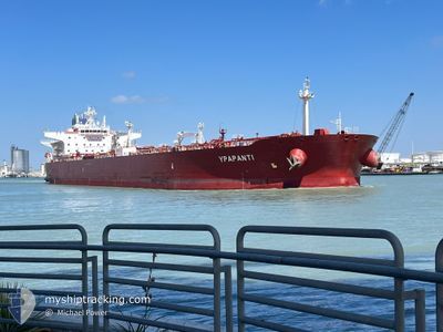
YPAPANTI
Tanker

Current Trip
SA YNB
| Time Travelled | 3 days |
|---|---|
| Remaining Time | --- |
| Distance Travelled | 3.47 nm |
| Remaining Distance | --- |
| AVG Speed | 15.3 Knop |
| MAX Speed | 15.3 Knop |
| AVG Wind | 6.7 knots |
| MAX Wind | 13 knots |
| MIN Temp | 24.8°C / 76.64°F |
| MAX Temp | 32.8°C / 91.04°F |
| Djupgående | 12.9 m |
| Position mottagen | 1 d sen |
Current Position
| Longitud | 38.20493° |
|---|---|
| Latitude | 23.93982° |
| Status | At anchor |
| Fart | |
| Kurs | 144° |
| Område | Red Sea |
| Station | T-AIS |
| Position mottagen | 1 d sen |
Information
The current position of YPAPANTI is in Red Sea with coordinates 23.93982° / 38.20493° as reported on 2025-04-09 11:40 by AIS to our vessel tracker app. The vessel's current speed is 0 Knop
The vessel YPAPANTI (IMO: 9693082, MMSI: 249279000) is a Tanker It's sailing under the flag of [MT] Malta.
In this page you can find informations about the vessels current position, last detected port calls, and current voyage information. If the vessels is not in coverage by AIS you will find the latest position.
The current position of YPAPANTI is detected by our AIS receivers and we are not responsible for the reliability of the data. The last position was recorded while the vessel was in Coverage by the Ais receivers of our vessel tracking app.
The current draught of YPAPANTI as reported by AIS is 12.9 meters
Weather
| Temperature | 30.1°C / 86.18°F |
|---|---|
| Wind Speed | 10 knots |
| Direction | 254° WSW |
| Pressure | 1006.9 hPa |
| Humidity | 50.6 % |
| Cloud Coverage | 17 % |


Featured Company
Last Port Calls
| Port | Arrival | Departure | Time In Port |
|---|---|---|---|
| 2025-04-02 06:36 | 2025-04-07 01:21 | 4 d | |
| 2025-03-27 06:44 | 2025-03-27 15:50 | 9 h | |
| 2025-03-09 08:41 | 2025-03-09 18:05 | 9 h | |
| 2025-03-08 14:45 | 2025-03-08 19:56 | 5 h | |
| 2025-02-24 06:20 | 2025-03-01 10:20 | 5 d |
Last Trips
| Origin | Departure | Destination | Arrival | Distance | |
|---|---|---|---|---|---|
| 2025-03-09 18:05 | 2025-04-02 06:36 | 2118.65 nm | |||
| 2025-03-09 18:05 | 2025-03-27 06:44 | 1474.77 nm | |||
| 2025-03-08 19:56 | 2025-03-09 08:41 | 121.73 nm | |||
| 2025-03-01 10:20 | 2025-03-08 14:45 | 1128.00 nm | |||
| 2025-01-22 17:39 | 2025-02-24 06:20 | 3067.91 nm |
Events
| Tid | Event | Detaljer | Position / Dest | Information |
|---|---|---|---|---|
| 2025-04-10 00:08 | STOPPAR förflyttning | 0.85 nm, South of YANBU |
23.93895 / 38.20402
SA YNB
|
Fart: Kurs: 108° |
| 2025-04-10 00:00 | STARTAR förflyttning | 0.87 nm, South of YANBU |
23.93887 / 38.20366
SA YNB
|
Fart: 10.6 kn Kurs: 258° |
| 2025-04-09 12:44 | STOPPAR förflyttning | 0.77 nm, South of YANBU |
23.94000 / 38.20527
SA YNB
|
Fart: Kurs: 156° |
| 2025-04-09 12:41 | STARTAR förflyttning | 0.77 nm, South of YANBU |
23.94001 / 38.20525
SA YNB
|
Fart: 52 kn Kurs: 256° |
| 2025-04-09 11:46 | Status ändrad | Default At anchor |
23.93986 / 38.20499
SA YNB
|
Fart: Kurs: 144° |
| 2025-04-09 11:40 | UTANFÖR täckningsområde |
23.93982 / 38.20493
Red Sea
|
Fart: Kurs: 256.2° |
|
| 2025-04-09 11:16 | Status ändrad | At anchor Default |
23.93983 / 38.20496
SA YNB
|
Fart: Kurs: 144° |
| 2025-04-09 11:07 | I täckningsområde |
23.93983 / 38.20496
Red Sea
|
Fart: Kurs: 256.2° |
|
| 2025-04-06 22:31 | STOPPAR förflyttning | 0.79 nm, South of YANBU |
23.93914 / 38.20760
SA YNB
|
Fart: 0.1 kn Kurs: 213° |
| 2025-04-06 22:21 | AVGÅTT HAMN |
|
23.94106 / 38.21111
SA YNB
|
Fart: 2.6 kn Kurs: 229° |