
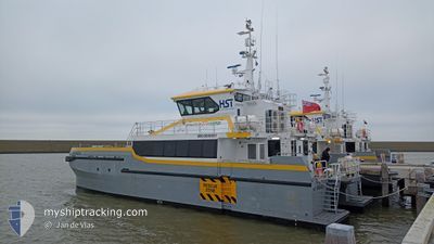
HST SWANSEA
High speed craft
Current Trip
| Trip Time | 7 h, 22 mins |
|---|---|
| Trip Distance | 118.47 nm |
| AVG Speed | 13.5 Knots |
| MAX Speed | 19.5 Knots |
| Draught | 1.5 m |
| AVG Wind | 17.8 knots |
| MAX Wind | 23 knots |
| MIN Temp | 10°C / 50°F |
| MAX Temp | 12.4°C / 54.32°F |
| Position Received | 1 m ago |
Current Position
| Longitude | -5.04238° |
|---|---|
| Latitude | 51.71345° |
| Status | Under way using engine |
| Speed | |
| Course | 194° |
| Area | Celtic Sea |
| Station | T-AIS |
| Position Received | 1 m ago |
Info
Information
The current position of HST SWANSEA is in Celtic Sea with coordinates 51.71345° / -5.04238° as reported on 2025-03-21 20:27 by AIS to our vessel tracker app. The vessel's current speed is 0 Knots and is currently inside the port of PEMBROKE.
The vessel HST SWANSEA (IMO: 9958951, MMSI: 232046426) is a High speed craft It's sailing under the flag of [GB] United Kingdom.
In this page you can find informations about the vessels current position, last detected port calls, and current voyage information. If the vessels is not in coverage by AIS you will find the latest position.
The current position of HST SWANSEA is detected by our AIS receivers and we are not responsible for the reliability of the data. The last position was recorded while the vessel was in Coverage by the Ais receivers of our vessel tracking app.
The current draught of HST SWANSEA as reported by AIS is 1.5 meters
Weather
| Temperature | 10.3°C / 50.54°F |
|---|---|
| Wind Speed | 18 knots |
| Direction | 118° ESE |
| Pressure | 996.1 hPa |
| Humidity | 93.1 % |
| Cloud Coverage | 100 % |
Featured Company
Last Port Calls
| Port | Arrival | Departure | Time In Port |
|---|---|---|---|
| 2025-03-21 15:38 | |||
| 2025-03-20 22:31 | 2025-03-21 08:16 | 9 h | |
| 2025-03-20 17:35 |
Most Visited Ports (Last year)
| Port | Arrivals | |
|---|---|---|
| 181 | ||
| 54 | ||
| 20 | ||
| 2 | ||
| 1 | ||
| 1 |
Last Trips
| Origin | Departure | Destination | Arrival | Distance | |
|---|---|---|---|---|---|
| 2025-03-21 08:16 | 2025-03-21 15:38 | 118.47 nm | |||
| 2025-03-20 17:35 | 2025-03-20 22:31 | 80.99 nm |
Events
| Time | Event | Details | Position / Dest | Info |
|---|---|---|---|---|
| 2025-03-21 16:44 | STOP Moving |
51.71339 / -5.04233
[GB] PEMBROKE
|
Speed: 0.3 kn Course: 205° |
|
| 2025-03-21 16:41 | START Moving |
51.71191 / -5.04131
[GB] PEMBROKE
|
Speed: 6.2 kn Course: 336° |
|
| 2025-03-21 16:07 | STOP Moving |
51.71046 / -5.03940
[GB] PEMBROKE
|
Speed: 0.3 kn Course: 336° |
|
| 2025-03-21 16:03 | START Moving |
51.70385 / -5.03318
[GB] PEMBROKE
|
Speed: 10 kn Course: 306° |
|
| 2025-03-21 16:01 | STOP Moving |
51.70300 / -5.03029
[GB] PEMBROKE
|
Speed: 0.3 kn Course: 23° |
|
| 2025-03-21 15:38 | PORT ARRIVAL |
|
51.70377 / -5.03455
[GB] PEMBROKE
|
Speed: 1.3 kn Course: 330° |
| 2025-03-21 14:40 | Change Sea Area | United Kingdom part of the Celtic Sea United Kingdom part of the Irish Sea and St. George's Channel |
51.72057 / -5.33487
Celtic Sea
|
Speed: 18.6 kn Course: 152.8° |
| 2025-03-21 14:39 | Status Changed | Under way using engine Default |
51.72520 / -5.33905
GREAT YARMOUTH
|
Speed: 18.2 kn Course: 154° |
| 2025-03-21 14:36 | IN Coverage |
51.72057 / -5.33487
Celtic Sea
|
Speed: 18.6 kn Course: 152.8° |
|
| 2025-03-21 09:06 | OUT of Coverage |
53.15948 / -4.79671
Irish Sea and St. George's Channel
|
Speed: 16.6 kn Course: 192.3° |